FAQs
The following are frequently asked questions regarding the Baylands development:
- Where is the Baylands and who owns the property?
- What does the General Plan allow on the Baylands?
- What is a Specific Plan?
- What is a Development Agreement?
- What is the environmental review process and how does it relate to the Specific Plan and Development Agreement?
- Is the City of Brisbane the only agency with approval authority over development of the Baylands?
- How can I stay informed about future meetings regarding, or information related to, the Baylands?
- How quickly is development likely to happen?
- Where can I find more information, including past studies and community engagement, prior to December 2018?
You may also direct comments or questions regarding the Baylands to cityclerk@brisbaneca.org.
1. Where is the Baylands and who owns the property?
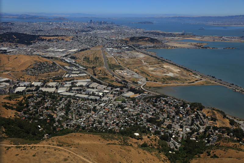
The Baylands Subarea as defined in the City's General Plan is a 600-plus acre area bordered on the west by Bayshore Blvd, north by the City and County of San Francisco, east by U.S. 101 causeway, and south by the southern end of the Lagoon.
The property is primarily owned by Universal Paragon Corporation (UPC). Other owners include Golden State Lumber and the Kinder Morgan Tank Farm.
2. What does the General Plan allow on the Baylands?
The City’s General Plan defines a vision for the future physical development of Brisbane and establishes a legal framework to ensure that land use decisions are consistent with that vision. In November 2018, Brisbane voters approved Measure JJ to amend the General Plan as it pertains to the Baylands.
The General Plan as amended allows for a range of 1,800 - 2,200 residential units limited to the northwest corner of the Baylands and up to 7 million square feet of new commercial development. See map here.
The General Plan further requires the following policies to be addressed in the future development of the Baylands:
- development must support ground level residential uses and comply with the associated higher level remediation standard;
- secure an adequate water supply;
- require that future development be revenue positive for the City;
- incorporate sustainability principles;
- protect key habitat areas; and
- address flood protection and sea level rise.
In order to implement the General Plan, the property owner will submit a Specific Plan and Development Agreement for review and approval by the City of Brisbane. The City of Brisbane will also prepare an environmental impact report (EIR) to evaluate the impacts of the Specific Plan and Development Agreement.
The Specific Plan is a tool to implement the General Plan for particular geographical areas. The Specific Plan must be consistent with the General Plan. Subsequent development projects within the area must be consistent with the adopted Specific Plan. The Specific Plan runs with the land, and any future or subsequent land owner(s) will be subject to the Specific Plan.
The requirements for a Specific Plan are established under State law. A Specific Plan must specify all of the following in detail:
- Distribution, location and extent of land, including open space, within the area covered by the plan.
- Proposed distribution, location, extent and intensity of major components of public and private transportation, sewage, water, drainage, solid waste disposal, energy, and other essential facilities proposed to be located within the area covered by the plan and needed to support the land uses described in the plan.
- Standards and criteria by which development will proceed and standards for conservation, development, and utilization of natural resources.
- A program of implementation measures including regulations, programs, public works projects, and financing measures necessary to carry out the matters listed above.
- Financing of Capital Projects – Regional capital improvements such as the Hwy 101 Candlestick Interchange and Geneva Avenue extension will require multiple funding sources. The Specific Plan will need to discuss the timing and funding of these regional improvements.
4. What is a Development Agreement?
5. What is the environmental review process and how does it relate to the Specific Plan and Development Agreement?
Once a Draft Specific Plan and DA are submitted to the City, the City will commence preparation of an environmental impact report (EIR) pursuant to the California Environmental Quality Act (CEQA). The EIR identifies and discloses the potential environmental impacts of the Specific Plan and DA, and identifies mitigation measures to minimize any such impacts.
Once the draft EIR is prepared, it will be made available for public review and comment. Any written comments received on the draft EIR will receive a written response. The Final EIR (consisting of the Draft EIR, written comments and responses thereto, and any changes to the EIR resulting from the comments and responses) will be published. Ultimately public hearings will be held before the Planning Commission and City Council on the Final EIR, Specific Plan, and DA.
6. Is the City of Brisbane the only agency with approval authority over development of the Baylands?
While the City of Brisbane has controls land use of the Baylands, there are a number of state and regional agencies with authority over some aspects of future Baylands development, particularly in regard to existing contamination found at the site due to historic landfill and rail yard uses that occurred there.
The site is divided into 3 sub areas for purposes of the remediation of soil and groundwater contamination: the former landfill area east of the railroad, Operable Unit (OU-1) located west of the railroad and north of Geneva Avenue (extended), and Operable Unit 2 (OU-2) located west of the railroad and south of Geneva Avenue (extended). Each sub area has unique cleanup requirements and numerous studies have been completed or are underway to identify contamination issues and recommend remediation options. The Department of Toxic Substances Control (DTSC) is charged with adopting remediation plans and establishing remediation levels based on land use for OU-1, while the Regional Water Quality Control Board is responsible for OU-2. The Water Board and County Health Department have responsibility over the former landfill.
While the City does not have authority over site remediation, the City has been actively involved in reviewing and commenting on remediation efforts, and will continue to do so to ensure that the City's interests are protected. The General Plan includes policies setting forth the City’s expectations for remediation.
7. How can I stay informed about future meetings regarding, or information related to, the Baylands?
The City sends out a weekly email on Fridays afternoons called the Brisbane Blast which includes: City News, Upcoming Events, the following week's City Meetings, Signboard Postings, and a Social Media Spotlight. Sign up for that here, and any other topic areas of interest related to the Baylands, and we'll make sure you stay informed as we move through the Baylands review process.
8. How quickly is development likely to happen?
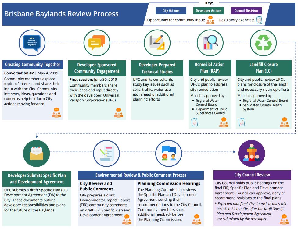
A diagram illustrating the overall Brisbane Baylands review and approval process can be found here or clicking the image below. The timeline is difficult to predict, as many steps in the process are dependent on how quickly or slowly the developer acts. If and when the Specific Plan is approved by the City, it will still take a number of years to complete all the needed engineering drawings and prepare the site for construction. Full build-out of the site is anticipated to take many years.
The City has created an official project site for the Brisbane Baylands, accessible at baylands.brisbanecalifornia.org. The Community Development Department has also kept records of Baylands meetings, studies, and input over the years on the Baylands Information page. Click here to access it.